


If your bridge display looks normal, but your vessel is not where it thinks it is, would you know in time?
That is the uncomfortable reality behind GPS jamming vs spoofing. Both are forms of satellite navigation attacks, and both can lead to operational disruption. But they work differently, show different warning signs, and demand different defences.
This guide explains spoofing vs jamming in plain terms, how they affect ships, how AIS vs GPS spoofing differs, and what practical steps help strengthen navigation resilience.
Spoofing vs Jamming explained
What is GPS jamming?
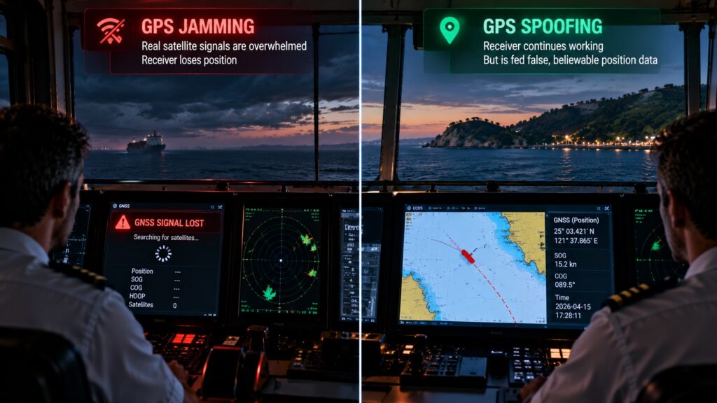
Jamming is deliberate interference that overwhelms GNSS signals. The result is degraded accuracy, loss of signal lock, or complete denial of service. This is why GPS jamming is dangerous for vessels: you can lose reliable positioning when you need it most, especially in confined or high traffic waters.
What is GPS spoofing?
Spoofing is more deceptive. Instead of blocking signals, it introduces counterfeit signals that make receivers compute a wrong position or time. This is how spoofing tricks ship navigation systems: the data looks plausible, so the error can compound quietly before crews notice.
The simplest way to remember the difference
- Jamming removes trust by causing loss or instability.
- Spoofing removes trust by creating believable falsehood.
That is the core difference between GPS spoofing and jamming in ships.
GNSS interference maritime risks
GNSS signals are weak by the time they reach a receiver. That makes them vulnerable to interference, especially in regions where electronic warfare is present. Industry guidance increasingly emphasizes redundancy and preparedness for GNSS interference maritime scenarios.
Operationally, the consequences are not limited to navigation. Disruption can affect timing, coordination, reporting, and bridge team confidence. In worst cases, the risk escalates to collision, grounding, or route deviation.
AIS vs GPS Spoofing: why both matter
AIS and GNSS play different roles. AIS broadcasts vessel identity and position over open radio frequencies. GNSS provides the underlying position and timing used by many systems.
- AIS spoofing can create false vessel identities or locations for tracking systems.
- GPS spoofing can alter the vessel’s own computed position and timing.
Both distort situational awareness, but in different ways. AIS issues can mislead external observers and traffic picture. GPS issues can mislead the vessel itself.
Practical warning signs crews can watch for
Early detection is often about inconsistency across sources. Typical cues include:
- Position jumps or slow drift that does not match visual bearings or radar picture
- Unusual alarms, loss of GNSS, or frequent re acquisition events
- Timing anomalies, especially when multiple systems rely on GNSS time
- AIS position discrepancies compared to radar or ECDIS track
Guidance from maritime safety and navigation bodies highlights the value of alternative position fixing and planned response procedures in high risk areas.
Defending against satellite navigation attacks
A strong posture is layered. It combines prevention, detection, and continuity.
1. Multi constellation, multi frequency reception
Using multiple constellations reduces single point dependence. It strengthens resilience when one signal source is degraded.
2. Signal verification and interference mitigation
Filtering and authentication techniques help reduce reliance on false data and suppress interference where possible.
3. Continuity through sensor fusion
When GNSS is degraded, continuity improves when navigation can draw on additional sensors and cross checks rather than collapsing into uncertainty.
Where Station Satcom fits
Station Satcom supports maritime and offshore operations with satellite communications, vessel IT, cybersecurity, and navigation communications solutions.
For navigation resilience specifically, Station Satcom can support deployments like the SafeCaptain Navigation System powered by SafePilot P1 and P1 Plus. SafeCaptain is positioned around high accuracy navigation and anti spoofing protection, with P1 Plus antennas designed to provide an added physical defense by blocking low elevation interference paths.
If you want to assess your exposure to GPS jamming vs spoofing and review practical mitigation options, write to sales@stationsatcom.com. We can share a short walkthrough of SafeCaptain with SafePilot P1 and P1 Plus and discuss how to strengthen navigation confidence on your routes.
FAQs
1. Which is harder to detect, jamming or spoofing?
Spoofing is often harder because it can look like a normal position update until inconsistencies appear.
2. Can AIS spoofing happen without GPS spoofing?
Yes. AIS can be spoofed independently because it is an open broadcast system, even if the vessel’s GNSS is accurate.
3. What is the fastest onboard check when something looks off?
Cross check position with radar, visual bearings, and independent sensors. Look for inconsistencies, not a single alarm.
4. Does adding redundancy actually help in contested areas?
Yes. Multi constellation reception and layered checks improve resilience and reduce single point failure risk.
5. What should operators do before entering a known interference region?
Brief bridge teams on risk, define alternative position fixing methods, and ensure a response plan is understood and practiced.